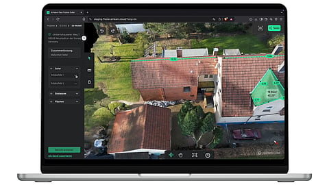

Airteam uses drones to capture building images for PV site measurements
Its software converts the imagery into 3D models with centimeter-level measurements
The workflow is also used in roofing, carpentry, scaffolding, and housing applications
Drones are increasingly used in the operation & maintenance (O&M) of installed PV systems at residential, commercial & industrial (C&I), and even utility-scale plants. A Germany-based company, Airteam, also uses drones, but for a different application: fast, accurate, error-free 3D measurements of buildings.
These measurements enable design and engineering planning of a PV system to be installed on rooftops. The idea is to replace conventional measuring tapes, CAD software, and reliance on satellite images. Airteam’s drone captures photos/videos of the building, which, when fed into its in-house software platform, Airteam Fusion, creates a 3D model along with the measurements. The measurement process, according to the company, takes around 10 minutes, which is about 10% of the time required for conventional manual measurements. The measurements are accurate to centimeter precision, and the generated 3D model can be exported directly to several PV design software tools, including PV*SOL, Eturnity, etc.
Integration with PV design software enables detailed layout plans, shading analysis, and yield forecasting in a short span of time. Additionally, these designs and plans can be connected to sales software to create professional offers with accurate 3D visualizations and yield forecasts. Airteam says the time required from inquiry to contract conclusion for a confirmed order will be reduced by 70%.
In addition to PV, the company’s solution has applications in other industries such as housing, roofing, carpentry, and scaffolding. Airteam claims its solution is used by over 5,000 companies in Europe, including over 1,500 PV installers.

